CHEROHALA SKYWAY
North Carolina
The Cherohala Skyway is a 36 mile long scenic highway
traversing nearly 6,000 foot tall deeply forested mountains in North Carolina
and Tennessee. The road travels through bith the Cherokee National Forest and
the Nantahala National Forest from which its name "Chero…hala" was taken.
There is little evidence of civilization from the spectacular views enjoyed on
the Cherohala Skyway.
Planning began for the Cherohala Skyway in 1958, and after
over 30 years of construction and over 100 million dollars the road was opened
to the public in October 1996 just in time for a spectacular fall color season!
This paved two-lane road was declared a North Carolina Scenic Byway in April
1997 and was later declared a National Scenic Byway.
The Cherohala Skyway connects Robbinsville, North Carolina
with Tellico Plains, Tennessee. The road goes from Santeetlah Gap on the North
Carolina side to Santeetlah Overlook, elevation 5390, at mile marker 11.
Travelers are treated to spectacular long range mountain views along an
unforgettable 7 mile ride of the mountain tops to the Tennessee state line.
Visitors look down on the Appalachian Mountains and the Snowbird, Slickrock and
Joyce Kilmer Forests. Visitors can see as far as the distant mountains of the
Great Smoky Mountains National Park! There are more scenic vistas on the
Tennessee side offering views of the Cherokee National Forest. At mile marker
16 travelers begin the descent into the Tellico River basin. Some of the many
overlooks and their elevations are as follows:
|
Shute Cove, 3550 ft.
Obadiah Overlook
Santeetlah
Overlook, 5390 feet (highest elevation)
Big Junction, 5240 ft.
Haw Knob
Slopes, 4890 ft.
Stratton Meadows, 4320 ft.
Hoopers Bald, 5290
ft.
Spirit Ridge Beach Gap, 4490 ft.
Between East and West Rattlesnake
Rock, 4110 ft.
Bushy Ridge, 3750 ft.
Turkey Creek Overlook, 2630
ft. |
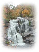 |
A detour may be taken to Bald River Falls on the paved
Forest Service Road 210. Water cascades over 100 feet onto the rocks below and
can safely be viewed from your car! There are a number of trails offering
hiking and close up views of the lush forests, with opportunities for wildlife
viewing. The Tellico River flowing through the lower elevations on the
Tennessee side is famous for its trout fishing. Following the river the road
brings you to the town of Tellico Plains Tennessee. Then you will enjoy an
encore of the fabulous drive on your return to North Carolina!
|